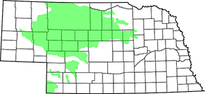
The Nebraska Sandhills region is the largest sand dune formation in the Western Hemisphere, spanning over one-fourth the total land area of Nebraska. Formed after the last Ice Age when winds blew the loose sand deposited by retreating glaciers, the Sandhills were shaped into dunes as high as four hundred feet and stretching over twenty miles across the landscape.
Native grassland covers 19,600 square miles, or 95% of the wind-deposited sand dunes. Its geology makes the area rich for wildlife, water and ranching.
Many people think of the Sandhills as dry, arid country, but the region is sitting on top of a billion acre-feet of water in the Ogallala Aquifer. The dunes act like a giant sponge that quickly absorbs precipitation, allowing very little to run off. The Sandhills contain many sub-irrigated meadows between the dunes where the water is close enough to the surface for plant roots to reach it. These meadows are used by ranchers for cattle-grazing and haying. Water percolating to the surface has created thousands of lakes and tens of thousands of wetlands ranging from small ponds which dry up in the summer to mile-long reservoirs. Most of the Sandhills lakes are shallow and less then ten acres in area.
Because of the wide variety of plants growing in the Sandhills, much animal diversity can be found there as well. It is the central flyway for migrating birds, including a number of birds, which are becoming increasingly rare. Both small and large mammals make their home among the dunes and meadows from Ground Squirrels, Kangaroo Rats and Porcupines to White-tail and Mule Deer, Pronghorn Antelope and Bison.
Ranching has proven to be the best economic and environmental use of the Sandhills and there, ”˜cattle is king’. In the 1870s, cattlemen came to the area and found it perfect for pasturing and raising cattle. The area was largely settled due to the 1904 Kinkaid Act, which allowed homesteaders to claim 640 acres of land, while the1862 Homestead Act only allowed 160 acres to be claimed. Between 1910 and 1917, nearly nine million acres were claimed under this act.However, many of these ranches broke up shortly afterwards, due to regulations that would not allow ranchers to fence federal range lands. Those who stayed found the land was excellent cattle country. In the early 2000s, the area had around 530,000 beef cattle. In fact, Cherry County, located in the Sandhills region, was the top cow county in the nation, with nearly 166,000 cows.
Retrieved from:
U.S. Fish and Wildlife Service
TheNebraskaSandhills.com
Progressive Cattleman
Photos retrieved from:
Wikimedia: The and Hills in the Fall
Wikimedia: Summer in the Sandhills
Map retrieved from:
Nebraska Geology Map


